Mar 31 2008

bearchel

We arrived in Big Bend National Park after spending some time with our friends in Fort Davis and Alpine TX. Unfortunately, Duane and Dona had to leave and go back to Dallas, Dona hurt her foot and had to go see the doctor, we wish her the best of recovery.

David and Lana came with us to see the Big Bend, like us, it was their first time there.

The first full day we decided to do a Jeep tour to familiarize ourselves with the area and what it had to offer. We were lucky enough to meet our guide “extraordinaire”, Elizabeth.

Elizabeth

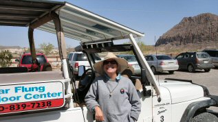
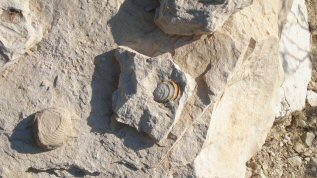
This tiny lady drove the jeep on the steep rocky bad roads like there was nothing to it, and her knowledge of the area was extensive. Thanks to her, we learned that to appreciate the desert, you have to look up-close. An overview from the highway is not enough, you do need to get up close and personal with the desert. It hides tiny signs of life, fossils hidden in the rocky soil and a rich fauna.

This is really the “Last Frontier”, the people here have a “pioneer” spirit, they are independent and resourceful. When you buy a land parcel here, and you want to build a house, you better be prepared to build it yourself. You may end up living in a tent of an RV trailer for months, while you are building. There are no building codes, so you are free to come up with the most unusual ideas and put them to use. The closest building material supplier is about 400 miles away in Del Rio and there are no construction companies in the Big Bend area. Most people, unless they want to build their house directly on the side of the highway, are living off-grid. Solar systems and windmills are used to provide electricity, rain water is collected in cistern systems to fill the water needs.. Wells are cost-prohibitive, and the ground water is too alkaline to be used without extensive water treatment. When we were there, there had been no rainfall since the previous September, so water conservation is a must. Kids living here are frequently home-schooled, although there is a school in the area. People help each others, like in the old days. Needles to say, if you want peace and quiet, if you want to live off-grid, and you don’t mind the dryness, the wind, the heat and the dust, this would be paradise.

Elizabeth, our guide, fell in love with the area while traveling here, she used to work for 5 or 6 years and save money enough to take 1 or 2 years off to travel the world. Strangely, she said that it never hurt a career, on the contrary, employers found it intriguing and appreciated the qualities that come with this kind of independence. She now lives here during the winter, works two part-time jobs, and then goes to North Carolina in the summer where she holds another job, she said that it was not uncommon for people to do this in the area.

The Big Bend area used to be a sea, billions of years ago, that is why most of the soil is composed of sandstone and the sea creatures fossils are abundant.

fossilsfossils

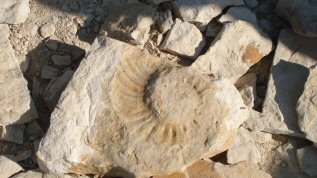
The sea moved to the south and the soil dried up, then intense volcanic activity took place, approximately 17 million years ago, pushing magma through cracks in the ground to form dikes, great stone fences that can be traced for miles across the park. Waves of magma underground formed the rounded mountains, and angular blocks resulted in stratified layers of lava and ash, the scenery is living proof what was once a giant volcanic battleground.

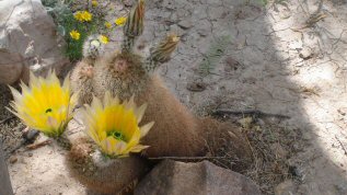
Depending on the elevation, the vegetation changes dramatically, you go from the lower plains, where the vegetation is sparse, composed mostly of creosote bushes, and as you go up, there are more and more variety of desert plants, to finally end up at high elevation in a forest of junipers, oaks and Mexican Piñons, if you hike even higher, you would find Douglas Firs and Arizona Pines. The change is so dramatic, that by looking at what variety of plants is growing, you can guess your elevation.

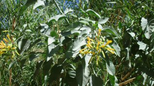
This used to be Apache territory, and the Indians knew how to use the land and its resources, most plants growing here have many uses, as food, medicine, sewing and building material.

Although the bare desert may look like a no-mans land, when you mix desert vegetation with gigantic rocks in tones of ochre, burnt sienna and rust, you end up with the most magnificent landscape, one that could compete without a problem with the best work of landscape architects.

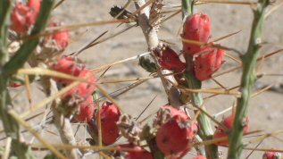
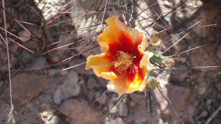
We were there while the Ocotillo was in bloom, I totally fell in love with this one, and on top of that the blooms are edible! Full of vitamin C! Many of he cacti were also beginning to bloom.

bloomingblooming
bloomingblooming

David and Lana have a 4 wheel-drive vehicle so we hopped in with them and they took us on remote, rough gravel roads. We hiked trails (and Bear did very well). At the end of a trail, hidden in a canyon, we found this dry waterfall, look at the sheer size of it.

The last day we hiked a 2 mile trail, including a quarter mile climb at the end, up a very steep rocky trail to go see the “window rock”, a gigantic boulder balancing itself on top of 2 other boulders, it was a tough climb and my legs still feel the effect, but it was worth it. Bear waited for us at the foot of the hill, it would have been foolish for him to risk dislocating a hip or braking on of his knees on this trail, but he had company, there are a lot of people who decided not to attempt the climb.

Farming took place here, when the desert was a giant grassland in the 1880’s after the Indians were pushed out of the area. Overgrazing killed the grass and by the mid 1900’s, the farms were abandoned, there are still ruins of adobe buildings and working windmills and wells that are left from this era. Around the wells that are still working, the vegetation forms little oasis for plants and animals, strangely the temperature is noticeably lower and breezy in those areas.

The Rio Grande (or Rio Bravo as our Mexican neighbours call it) is the border between the United States and Mexico.

Average Rating: 4.8 out of 5 based on 292 user reviews.


Feb 27 2008

bearchel


Images of Texas

This one will be short and sweet, just a few images captured along the way.

beaches
Beaches as far as the eye can see…

Pelicans
White Pelicans must be social birds, they flock together to get some sun on the piers

windwind
Winds so strong, they make oak trees grow sideways

windmill
Windmill blades blown by a hurricane and embedded in a tree.

sunsetsunset
Move over Key West, check out the Texas sunset!

Drive Thru
When they call a it a “Drive Thru” in Texas, they mean it!

Platform

“Texas-size” tow job.

They were towing this Chevron oil platform all the way to South of Louisiana where it will sit in 7 thousand feet of water.

horns
Only in Texas…

Enjoy!


Average Rating: 4.5 out of 5 based on 231 user reviews.


Feb 17 2008

bearchel

We arrived in Louisiana Monday and settled in our little campground near Abita Springs in the St. Tammany Parish.

This Parish is situated on the north shore of Lake Pontchartrain which was named after the Count de Pontchartrain who served as a Minister of France during the reign of King Louis XIV, the “Sun King” after which Louisiana is named. The lake is 40 miles long and 25 miles wide, it covers 625 square miles. It’s average depth is about 15 feet. The water is brackish and the bottom of the lake is covered with clam shells. It is home for over 125 species of fish, the bay anchovy being the most common.

The Choctaw nation used to live here, as early as 1600 BC. St. Tammany economy flourished with the influx of tourists from New Orleans, who came here “de l’autre coté du Lac” (the other side of the lake) to experience the clean air and artesian water which was reputed as having healing powers by the Indians. This same water is now the key ingredient in two thriving parish products, Abita Beer and Abita water. (Abita beer is pretty good, we sampled it last night when we went to Abita Beer Brew Pub and they also serve quite a good selection of Cajun dishes so it was a delicious dinner).

St. Tammany Parish is also known as and equestrian parish. The rolling hills of Folsom are the breeding and training grounds for many Arabian and thoroughbred horse farms, as well as home to exotic animal farms, including Llamas, Ostrich, miniature horses and more.

New Orleans is sandwiched between the Gulf of Mexico to the south and Lake Pontchartrain to the north. To access the North Shore if you were in New Orleans, you would have to cross Lake Pontchartain causeway bridge, which runs 23.87 miles north bound and 23.86 miles on it’s south bound span. It is the Nation’s longest over the water highway bridge. (I am pretty sure it is the second longest bridge over water in the world, but don’t quote me on that one). Since Doug is afraid of bridges, we didn’t even try to cross this one!

Lake Pontchartrain
View of Lake Pontchartain and the Causeway Bridge

Baton Rouge

Maybe the most interesting part of traveling through Louisiana is learning about its history. I was never a history buff, but I learned surprising things during our visit to Baton Rouge, the Louisiana State Capital.

Baton Rouge is a very nice city, we felt secure walking around and sight-seeing. There is a Trolley in the Historic part of downtown, it runs from 10 AM to 2 PM, it is totally free, and it will take you from one attraction to the other.

We first visited the old Capitol building. It is surrounded by an impressive cast-iron fence, cast and erected in 1855 by the John Hill Foundry, it is unique in the fact that it is constructed entirely of interlocking parts, the only bolts used are the ones to anchor it to the iron base plates. It is on the list of the 10 most endangered sites in Louisiana, the rust and water having caused serious damages. It spans 1575 feet and surrounds the 5 acres tract around the Old State Capitol. It is undergoing an extensive preservation and repair effort.

Fencefence

This 150 years old building, built in a blend of Gothic and Victorian architecture styles withstood war, fire, scandal, bitter debate, abandonment and an occasional fistfight. The building was reborn as the Center for Political and Governmental History in 1994. It features a gorgeous cast-iron staircase (1882) , black and white fossilized marble floor, intricate brass hardware, faux-bois and gold leafing, stained-glass windows and a magnificent stained glass cathedral dome(1882). On the grounds, you can also see a Ginko tree planted in 1857.

Old Capitol buildingdome
The old Capitol building and its stained-glass cathedral dome.

The Center is the repository of film and video archives and houses state-of-the-art interactive exhibits and a multimedia presentation. We listened and watched old political speeches from famous Louisiana politicians like Huey P. Long (he was quite a showman) and his brother Earl (famous for his affair with the stripteaser Blaize) and others. We also learned about the history of Louisiana and I was blown away by what I learned.

A bit of history

Permanent settlement by Europeans in present day United States started with the establishment of a colony in St. Augustine, Florida, by the Spanish in 1545. The French soon followed and in 1682, Sieur de Lasalle, claimed the entire Mississippi river valley for France. He named it Louisiana, in honor of King Louis XIV. The Dutch and English also established colonies in America, mostly North East. Most of Canada and all of Louisiana was clearly French, Spain dominated the South West and Florida, and the English clung to their 13 colonies on the Atlantic East Coast. Since they all couldn’t get along, in 1754, the war started and the British won. In 1763, Britain ruled Canada and Florida, France, humiliated by its defeat, compensated her ally Spain for the loss of Florida by transferring Louisiana to the Spanish Crown.

Well, the Spanish soon discovered that they were not making any money with the colony, in fact, it was costing them money, so they gave it back to France.

The newly formed Republic, the United States of America, emerged as an independent nation in 1783, and they figured that they needed the Port of New Orleans for economic growth and survival, so, Thomas Jefferson sent an envoy to meet with Napoléon Bonaparte and negociate the purchase of New Orleans. At that point Napoléon was very busy trying to conquer most of Europe and that was costing a lot of money, Louisiana was a drain on his finances and he really didn’t care for it at all. All he cared about was money for his military conquests, so when the envoy from the United States arrived to negociate the purchase of New Orleans, the French representant of Napoléon told them it was all fine as long as they would accept to also buy the entire territory of Louisiana. After much debating and negotiating, they finally agreed on a price for the whole deal, 50 million francs (15 million dollars). So on April 30 1803, Louisiana became a part of the United States. Now until I visited this museum, I always thought of the Louisiana territory as what it is today, that is, the territory occupied by present-day Louisiana, but I was dead wrong! Oh boy was I ever wrong!

Now look at the picture and that is what Napoléon sold to the United States for 15 million dollars…..

The Louisiana Purchase
The Louisiana purchase.

Yup, you are seeing right, Louisiana covered 827, 987 square miles and would later make up all or part of 15 States. That my friends, is a bargain! And to think that some Americans were against the deal!

Well, this opened the route to the West and the rest, as we say my friends, is history…. 😉

The old governor house

We then took a tour of the Old Governor House.

Old Governor houseGovernor house

This is the second “Governor House” on these premises, this one was built for Governor Huey P. Long in 1930 at the cost of $150, 000 dollars. It is 20, 000 square feet and has 7 bedrooms, all with their own private bathroom. There was an earlier house on this land, but Governor Long didn’t find it suitable, he tried to have another one built earlier but didn’t get the approval of the congress, so he had the old house declared “condemned” and then tried again to get the funds for the new house, and this time, he was successful.

This house is often referred to as “Louisiana’s White House”. It was occupied from 1930 until 1962, when Governor Davis moved to another house, closer to the new State Capitol. This house has no air conditioning and it would have cost 2 million dollars to retrofit it with AC, so Governor Davis figured they could build a new house for less than that.

Governor Davis by the way, was also a Country Music Star, and he is the one who wrote the song “You are my sunshine”.

Governor Davis Bed
Governor Davis Bed

The walls of the house are plaster, and some rooms are painted with faux-finish, but the dining room is covered with a French Wallpaper depicting scenes from various ports of the United States as seen in the 1600’s.

Wallpaper

On the Mississippi river, sits the USS Kidd DD-661, an old WWII ship that is also part of the Veterans Museum.

USS Kidd

We didn’t have the time or energy to go visit other sites in Baton Rouge, there are many others including the new Capitol building, the Casinos, the doll museum and so on. The whole area of Baton Rouge is surrounded by old Plantations and most of them are opened to visitors, some of them offer meals and sleeping accommodations.

Today is my birthday and we are staying home, preparing for tomorrow’s trip, we are leaving for Texas, and hopefully the weather will cooperate because the last few days, we’ve gone through multiple severe thunderstorms, 2 hail storms, a tornado watch, cold and nasty weather. I am happy to report that it is now warm and sunny 🙂

Average Rating: 4.4 out of 5 based on 283 user reviews.